

If you choose to switch from a Google phone or Apple iPhone to something else—so that you don't reward those companies—that's a good reason to switch. But don't do it thinking you can't be tracked.
Last week, Brian Cates (@drawandstrike on Telegram, @BrianCates on Truth Social) asked me what I thought about the new "Google-free" phones in the context of a conversation that we were having about location privacy.
This issue is on the minds of many of us as we wrestle with what geo-location tracking data means—in both the positive sense (2000 Mules) and the negative sense (Chinese social credit systems.)
Concerning the "non-Google, non-Apple" phones: While these new phones may give you a way to strike back at the Tech Giants by not financially supporting their businesses and ecosystems and perhaps avoid some of the targeted marketing and cookie tracking these behemoths are famous for exploiting, don't make the mistake of thinking that your privacy (in particular, your geo-location) is necessarily protected.
In this article, you are going to learn a lot that you may not have known about location tracking and cell phones (there's also an easter egg at the end that is not a cell phone feature), and you'll leave this post being much more aware of what's going on in the world as a result.
I recently wrote about this location tracking topic in the article; The Surveillance State is Worse than you Think. I also touched on these ideas in the Anti-social Media posts parts 1 and part 2.
To set the context in brief:
"Social media platforms, as they evolved, first allowed the operators of those platforms to know who you know. That was valuable. Next, by adding location tracking from your phone using its GPS (and other!) sensors, they could figure out where you were. That was even more valuable.
But then, if they made note of when you were at a particular place, and also who else was in your immediate vicinity, using data from their phones—either at the same time, or shortly before, or shortly after you were there—well that information can be priceless.
Particularly if they could figure out whether you knew any of the people who were there at some particular location with you at that same point in time, and particularly if they could figure out where those people went after they were at some place near you."
For one particularly interesting case of how this kind of information could be valuable to solve cold crime cases, see this post involving the murder of Seth Rich and the New York Times.
"The topic of this substack post involves the use of geospatial tracking, which is actually a misnomer: it is actually more correct to refer to it as geospatial-time tracking. As Einstein taught us, spacetime consists of three space coordinates and one time coordinate, and all four matter."
We'll get into that last detail a little later.
This post will shed some light on all the ways that your smartphone, watch, and tablet devices can be used to locate and identify you. As you'll see, about the only way to be free from tracking is to wear a paper bag over your head and never carry any electronic gizmo of any kind with you anywhere—which is too extreme, in my opinion.
I suspect that a small minority of the "mules" in the 2020 election scam were smart enough to know to leave their electronics behind; which begs the question: if we caught 54,000 "dumb" mules who carried their phone with them, how many "smart" ones were involved to add to the total counts? Was there some other way of tracking them that they might have overlooked?
With respect to location-aware smartphones and apps: personally, I choose to take advantage of the modern conveniences that these technologies offer because they simplify my life while still being acutely aware of—and acknowledging—the downsides. And if I have an absolute need not to be tracked or recorded on video or audio…at least I have some ideas of how to make sure that is achievable if I desire it, given what I know of how the technology is designed.
There will eventually be a menu of legal and technological solutions that will give us more control over how our personal "metadata" like geo-location may (or may not) be used; there are already some good technology implementations that are beginning to appear. But it will take more time to wrestle with since this problem is relatively new to society. It's only been around for two decades (I know because I wrote one of the first preliminary patent applications for using GPS data from cell phones for marketing purposes in late 1999.)
America's founding fathers certainly didn't foresee this kind of technology back in 1787, so it is incumbent upon us now to create new constitutional protections for this sort of thing that layer on top of the ones they did have the foresight to provide for us.
Lets Dig In
As shown in this diagram, we will try to explain 'triangulation' (which is a technique for locating cell phones even without GPS). Still, before we can do that, we have to do some basic review of math that you (probably) learned in middle school and then promptly forgot. Especially if you drank heavily in college and then studied liberal arts and never again thought about algebra.
If math gives you the heebey-jeebies, you can skip a few sections to get to the rest of the discussion.
We're going to come back to this picture later, but I wanted you to see it first.

This next section gets just a bit technical, but I'll try to keep it as simple as possible. When we were in middle or high school, many of us learned about "graphs" using two "axes," typically the X-axis (left and right) and the Y-axis (up and down) when talking about 2-dimensional or 2D graphs.
Any position on the chart (like the red dot on the far left) could be described by giving a pair of numbers like (3,4), which means: go 3spaces in the X direction, and then 4 spaces in the Y direction. And then you'll get to the dot.

I suspect this gives some of you nightmares, but I'm sorry. We have to press on! We have a ways to go!
Later on, some of you who didn't burn out of math that easily also learned that you could use a third axis: the Z-axis. This lets you represent locations of points in "3D space".
In which case, every point could be described using a triplet of numbers like (3,4,7) which means: "go 3 steps along the X-axis, go 4 steps toward the Y-axis, and then go 7 steps up in the air, toward the Z-axis".
It turns out that there is another equivalent way to locate points in 3D, and pilots use a form of this. If I want to tell you how to get to a point 5 miles away up in the air from where you are standing, I could describe it with two angles and a range, like this:
"First, face the horizon and look due East. OK. Now, turn your body and look 17 degrees to the right (toward the south.) OK, stop. Now, lift your eyes 36 degrees upward from the horizon. OK, good. Now, the spot you are looking for is exactly 5 miles away on the line that you are now visually sighting along."
In this way, you can also specify any point in 3D space using two angles (an "azimuth" and an "elevation") and also "range" or distance.
OK, so that's enough of 2D and 3D algebra review.
It turns out that the GPS (which stands for Global Positioning System) chip in your phone continuously provides your "location" on a virtual map in more or less a 2-dimensional way, using map coordinates that are expressed in longitude and latitude. These are no different from the (X, Y) coordinates you used to love to hate in Algebra.

Suppose you imagine a particular region on a map. In that case, you can think of it as being a "polygon" (a random shape with some number of edges and an equal number of corners), and the "corners" can each be described using their respective (longitude, latitude) coordinates on the map.
You can think of "longitude" as the X coordinate on a 2D map and "latitude" as the Y coordinate on a 2D map.
You could imagine "building an imaginary fence" along the edges of this shape on the ground that the map is representing, in which case you'd have a "geofence."
Then you can ask a question like, "is the position of the yellow dot at (long0, lat0) somewhere inside the boundary—somewhere inside this geofence?" If it is, you can get more precise and ask: "If it is inside the geofence, how close is it to three or more corners?" If you know at least three distances from any set of corners, you can locate the yellow dot precisely with some simple geometry.
Here's where it gets more interesting, and for this, we're going to go back to 3D. Since the polygon of map coordinates is essentially just an (X, Y) plane shape, which tells you where you are on the map, then you can imagine that the 'Z-axis' could instead be used to represent time. It can tell you when you are on the map (this isn't exactly how geospatial works, but it is a good analogy to convey the concepts).

You could pick some arbitrary starting time as "time zero" and then imagine the times before and after this "time zero" as forming a 3D volume stretching up and down whose cross-section-the green area—is the geofence.
Now you can ask: is the yellow dot anywhere inside the geofence time volume?
If the answer is yes, it means that the yellow dot was in the geographical boundaries marked by the red corner dots, and it was also in this area between two chosen time markers, T1 and T2.
OK, so now we take a few leaps forward with this understanding. It turns out that when you ask geometry-like questions, "is point X within the boundary represented by the set of polygon vertices P1, P2, P3, PN…" you can use techniques from areas of mathematics called "set theory" and also "linear algebra," which has to do with the mathematics of things called "matrices" (which are just tools for analyzing things conveniently in terms of two-, three-, four- or more dimensions. It's more complicated than that, but this will do for now.)
It also turns out that there is a database system known as SQL ("SeeK-wull"), and under the hood, it heavily relies on the mathematics of both set theory and linear algebra to work its magic with databases and answering queries.
It turns out that with a few modifications, SQL databases—which weren't originally intended to deal readily with location data —were able to be adapted to answer geo-spatial-time queries (questions like: "was this GPS coordinate within the boundaries of this set of other GPS coordinates between time T1 and T2") fairly easily. Systems that deal with things like this are sometimes called "GIS" systems. (Geospatial Information Systems.)
OK, so now that we know how GPS-based Geofencing works at a really crude level, we have some idea at least that there is a SQL-like database system that's pretty good at figuring out if a given GPS/time location coordinate that you give it is inside or outside of a specified geofence/time boundary, we can press forward.
Your phone, it turns out, has a lot more sensors besides just GPS than most people realize, and *all* of these can be used to enhance its known position in space (and, therefore, land in a GIS system). This is the point that the leftist press is ignorant of when they (falsely) try to debunk the 2000 Mules data analysis.
A modern cell phone has a GPS receiver, which receives signals from a set of satellites in orbit. Using some special mathematics, we can determine based on the differences in time markers that are being broadcast from each of the GPS satellites where you are on a map. It is claimed that the non-military versions of GPS that the public uses can fix your position (typically) to within about 30 feet. Military versions are significantly more precise.
It turns out that 30 feet is not very precise; if you imagine trying to use GPS for driving and it can't tell where you are closer than 30 feet, you will be driving off the road constantly. Google Maps and other driving aids also use the map information they have compiled over the years to help correct the GPS signal; if you are driving on some highway, and the GPS signal "drifts" a few yards off of the highway, the driving app "corrects" your position because it presumes you're actually still on the road where the map indicated it should be. Therefore, the navigation system is constantly 'correcting' the GPS location.
But the other sensors on your phone can also be used to enhance location awareness. Your phone also has a magnetometer (it can sense magnetic fields like a compass, so it knows which way is "north"); it has an accelerometer, which can measure changes in speed; it has an inclinometer, which can measure angles as a spirit-bubble level does; it has an altimeter, which can provide altitude readings.
It turns out that if you combine the results of all of these other sensors—which way you are facing in terms of magnetic direction, what altitude you are at, etc. with information stored on the Google "Map," you can use them to also 'correct' for GPS drift and nail down your location even more precisely.
But there's more. A lot more.
A modern smartphone also has three or four "radios" of different types. One of these radios is for the cell phone tower network, e.g., AT&T, Verizon, or T-Mobile. Your phone is typically in contact with two or more of these towers at any one time, and as you drive, your phone constantly switches to try to "talk" to the tower nearest to you to maintain your call connection and quality. As you travel, your phone call is 'handed off' to the next nearest tower.
We'll double back to the idea of triangulation shortly, but suffice it to say that because of E-911 requirements, your cell phones have essentially always had the ability to fix your location well enough for emergency responders to find you. With 5G and "steerable antennas," it has gotten ridiculously more precise in theory. And that is true whether you have the GPS enabled or not. All that is required is for your phone to not be in 'airplane mode,' which means it's allowed to look for and signal to the nearby cell phone network towers. With ONLY that turned on, you can be tracked.
But there's still more.
Your phone also has a WiFi radio. This is used to connect you to the internet when you are in range of your home wireless hotspot or at a Starbucks or other store. This is completely different than the cell phone network. That WiFi radio *also* continuously tracks nearby transmitters; in fact, as you drive, your phone is picking up all of the hotspots along the way that are within a few hundred feet of your phone—the ones that your neighbors, schools, or businesses use inside their homes or offices.
It turns out that Google (and other mapping companies) collect information about WiFi signals with those funny looking cars that they send out that take pictures of the streets for street view maps for navigation systems; for each "point" on the map, they can determine what neighboring WiFi signals there should be at that point, and at what relative strength. This strength figure gives a rough indication of range/distance. (Google also got in trouble for using technology to siphon up the wireless passwords for those networks at one point. Bad Google. Bad.)
This WiFi information, too, can be used to refine or correct your phone's idea of its position. For instance, if your phone in your car is near 6th avenue and 18th street and Mrs. Smith's WiFi called "TrumpWon2020" in the home on the corner is in range of your phone, and if it is transmitting at a certain power level that indicates its relative distance, that fact can also be used to enhance the determination of your position.
But wait, there's more.
Your phone also has Bluetooth radios. These have a range of about 30 to 300 feet, whereas WiFi has a range of a few hundred to a thousand feet, and your cell phone network has a range of a few miles. But it turns out even these Bluetooth radios can (in theory) be used to fix your location. All your phone needs to do is detect the "beacon" from another Bluetooth transmitter whose GPS location is precisely known. Using signal strength, estimate your distance from that beacon to enhance your phone's location. If you don't think that there are "beacons" like this to detect location covertly, think again.
This capability of Bluetooth was exploited for those "COVID alert" apps that were being pushed in 2020/2021. The idea was that your phone would "beacon" out its Bluetooth identifier every so often and "remember" the IDs of other phones' beacons that it came across that were within 100 or so feet. Based upon signal strength and duration of proximity, it could then send information to the effect of "I was near a cellphone with Bluetooth ID XYZ, within 10 feet or less, for 15 minutes somewhere."
By putting this information in a public health directory, even if it was completely anonymous and did NOT track names or location, you could at least figure out whether you were exposed to the virus; if the owner of Bluetooth ID XYZ got sick, and this was captured in the public health directory, your app could query the public health directory to see if any of your captured beacons were noted as being sick.
That way, you'd at least know you should get tested because you were near somebody for an extended period of time who became ill—even though neither you nor the public health agency knew either parties' identity or the location where the contact took place. (In theory, whether they maintained privacy like this, in reality, is anyone's guess.)
Finally, there is one more radio: the NFC radio. This is extremely short range, and it's used in stores for things like "tap to pay." While it doesn't directly help in identifying your location while moving, if you use "tap to pay" at a store, then, in principle, the exact location of the payment terminal (if it's registered in a database somewhere, and most likely is) that, too can be used to fix your location at some point in time and space.
OK, so now let's go back to triangulation, and then I'll leave a surprise for you at the end with one more example of how your location can be tracked—WITHOUT YOUR PHONE. I want to be sure you read the whole article, so I'll leave an easter egg for you at the very end.
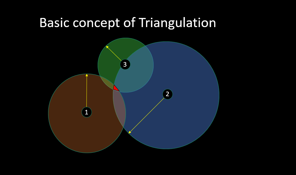
At the beginning of this post, I showed this graphic. Now that you have some basic understanding of things, I can explain it better. Suppose that the three points 1, 2, and 3 are cell phone towers, WiFi access points, Bluetooth radios, etc.
Each one of them can "see" your device (and your device can "see" them), and from the strength of the signal coming back to it, the transmitter can at the very least determine how far away from it you are ("determine your range").
In some cases, with sophisticated modern cell phone antennas, it might also be able to tell the angular direction your phone is in (either the "azimuth" or the "inclination.") Remember that two angles and a range can precisely locate a point, just like an X, Y, Z coordinate can.)
But let's set that aside and assume they can only determine your range. If each of the three "towers" can measure at least your phone's signal strength—which corresponds to your distance away from them—and if they then talk to each other to share this range information—or conversely, if your phone can measure the signal strength of each tower independently—then in both cases, you can draw "circles" that extend out from the radio at the known range which corresponds to a fixed distance. Where those circles overlap—the bright red region on the chart above—well, that would determine pretty precisely where your cell phone is located.
Either the network of towers can locate your phone, or in the same way, your phone can locate itself relative to the towers. Let me remind you that this form of location works if your phone is only enabled to allow cell phone calls; nothing else is needed.
It turns out that police and rogue spy agencies can also deploy "fake" cell phone towers that masquerade as AT&T and Verizon towers and use the same information to locate people they are interested in. They can also use things like Stingers. Again, these devices do NOT rely on your phone's GPS being enabled.
It turns out that this same triangulation technique also works for WiFi Hotspots, and now I'm going to tell you something that many of you may not know.
Why do you think so many stores and restaurants started offering you "free WiFi" at their locations? Do you think it was just so that you could read the news, or play words with friends while you waited for your table, or listen to music?
Nope.
It was because their WiFi networks could learn your phone's identity when you came into the establishment, which tells them how often you visit each month and how long you stay, just by watching for your phone's unique WiFi "Beacon."
In the case of stores like Target, which have used this technology for a lot longer, they can tell even more about you. By putting WiFi hotspots up in a grid in their stores, they can use triangulation software to follow you around as you wander through the store—to see what aisles you go to, how long you stay in them, what aisles you go to NEXT, what aisles you NEVER visit, and so on.
And then, when you go to the cash register to swipe your card and ring up your purchase, they can associate the details of your purchase—what you bought and how much you spent—with the WiFi identifier of your phone while you are standing right next to the credit card terminal that is capturing your payment information. So now, they have a 'trail map' of where you went in the store, how long you idled, and what you bought.
How many of you knew that they did that?
OK, now for the easter egg: your geospatial-time location can be tracked by another method that doesn't even require cell phones. If you have a newer-model vehicle, it probably has a dashboard indicator that shows you the tire pressure on each of your four tires. It turns out that sensor reading is sent from a chip inside your tire to your car's computer using wireless networking, much like Bluetooth. And that signal can be picked up some distance away.
One day, I visited a friend's house near Sacramento, and he had a Raspberry Pi computer in a box on his table, with wires attached to some gizmo. "Hey Ed, what is that for," I asked. And he told me that he uses it to sweep up the identifier signals for all of the tire pressure sensors from the cars that go by on the road outside his house.
Hmm. Just think about that for a moment… whose idea was it to put those convenient tire pressure sensors in your tires again? What might that be useful for?
Update: an astute reader on Truth Social, @modus17, points out that the example I provided with the three overlapping circles is properly called "trilateration" instead of "triangulation". I didn't want to make the explanation too complicated, so I blurred together two concepts. Both methods are used for location determination in different scenarios, but the chart I gave is for trilateration because of the shape of the intersection of 3 circles in 2 dimensions.
Here's a good quick summary comparing the two. Hat Tip to @modus17 !
This article first appeared on CognitiveCarbon's Content.
